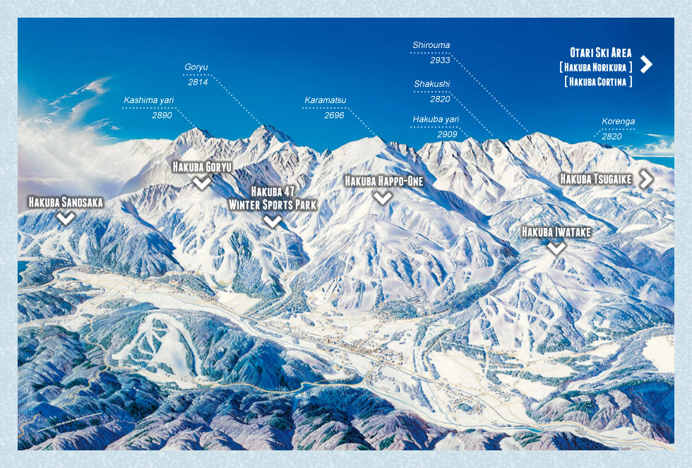
Hakuba valley ski resorts |
The Hakuba Valley is located (map) in the North of Nagano Prefecture.
It is easily accessed by the Nagano Shinkansen and then by road; or by direct bus or snow shuttle from Narita Airport.
The Hakuba Valley is drained by the Himekawa River flowing North into the Sea of Japan, and to the south by the Takase River which flows in a large loop south then northeast past Nagano becoming the Chikuma River, then the Shinano River before exiting in the Sea of Japan.
The most northerly of the ski areas, Cortina, is 36km[1] from the coast.
Hakuba was the site for alpine events in the 1998 Nagano Olympics, and now is a ski resort destination.
Ski areas
Almost all the ski fields are located on the north western side of the valley.
The list below is in south to north order.
| Ski Hakuba Valley
| Lifts
| Vertical m
| Highest m
| Beg/Int/Adv%
|
|
 View down a run under Sakka Kitaone
📷 Simon
Norikuracortina Course Map |
Norikuracortina Course Map |
|
| Hakuba village
|
| Happo One *
| 23
| 1,070
| 1,830
| 30/50/20%
| Happo One map
|
| Hakuba Goryu *
| 13
| 925
| 1,675
| 25/40/35%
| Goryu map
|
| Hakuba 47 *
| 6
| 794
| 1,615
| 30/40/30%
| Hakuba 47 map
|
| Iwatake[4] *
| 15
| 540
| 1,290
| 20/50/20%
| Iwatake map
|
| Otari Village
|
| Tsugaike Kogen *
| 20
| 904
| 1,704
| 50/30/20%
| Tsugaike map
|
| Hakuba Norikura *
| 10
| 600
| 1,400
| 30/50/20%
| Norikura Onsen map
Norikura Onsen map
|
| Hakuba Cortina *
| 7
| 530
| 1,402
| 40/30/30%
| Cortina map
Cortina map
|
| Omachi Village
|
| Kashimayari *
| 8
| 720
| 1,550
| 40/45/15%
| Kashimayari map
|
| Jiigatake *
| 4
| 260
| 1,200
| 70/30/00%
| Jiigatake map
|
| Hakuba Sanosaka *
| 5
| 460
| 1,200
| 40/40/20%
| Sanosaka map
|
Yanaba Snow Park
| 2
| 310
| 1,140
| 70/30/20%
| Yanaba map
|
* Hakuba Valley Pass
Gelande
Maps from 2015

Hakuba 47 Goryu

Happo-one

Sanosaka

Tsugaike

Cortina

Jiigatake

Kashimayari

Norikura Cortina

Norikura

Yanaba
More information

Hakuba valley map

Hakuba Valley Skifields
(:template first:)
| Name | 6x | 4x | 4 | 3 | 2 | Tbar | platter | rope | carpet | area | base | top | drop | terrain | aspect | opens | closes | link | ref | snow.co |
|---|
(:template each:)
| {=$:Name}? | {=$:chair6x} | {=$:chair4x} | {=$:chair4} | {=$:chair3} | {=$:chair2} | {=$:liftTbar} | {=$:liftplatter} | {=$:liftropehand} | {=$:liftcarpet} | {=$:area} | {=$:base} | {=$:top} | {=$:drop} | {=$:terrain} | {=$:aspect} | {=$:opens} | {=$:closes} | {=$:url}(approve sites) | [5](approve sites) |  |
(:template last:)
Key
2 3 4 6 chair size
x express chair
