Recent Changes - Search:

add Trips page

hide

Trips


hide

Topics


show

Changed

Visitor's book Site map pmwiki-2.3.33

2023-04-16 Moeraki Haast Paringa Cattle Track, Day 05

for photos pages for maps page for photos pages for main page for day pages add main page trail

add sub-page trail

Thursday 2023-04-20. day 05

Mataketake Hut to Blue River Hut via tops, drive to Waita River at the south end of Haast-Paringa Cattle Track, tramp to Coppermine Creek Hut

Morning packing in Mataketake hut
Photo: Simon
2023-04-20 08.30.08; '2023 Apr 20 08:30'
Original size: 9,248 x 6,936; 12,669 kB
Morning packing in Mataketake hut

Photo: Simon

Leaving Mataketake hut in the cloud
Photo: Philip
2023-04-20 08.46.31; '2023 Apr 20 08:46'
Original size: 4,320 x 2,880; 5,045 kB
Leaving Mataketake hut in the cloud
Photo: Philip
Bian and Simon taking the track from  Mataketake hut in the cloud
Photo: Philip
2023-04-20 08.53.25; '2023 Apr 20 08:53'
Original size: 4,320 x 2,880; 5,009 kB
Bian and Simon taking the track from Mataketake hut in the cloud
Photo: Philip
Simon and Brian on the Mataketake tops route in the cloud
Photo: Philip
2023-04-20 09.41.46; '2023 Apr 20 09:41'
Original size: 2,880 x 4,320; 4,301 kB
Simon and Brian on the Mataketake tops route in the cloud
Photo: Philip
Brian and Philip on the Mataketake tops route in the cloud
Photo: Simon
2023-04-20 09.48.18; '2023 Apr 20 09:48'
Original size: 9,248 x 6,936; 18,399 kB
Brian and Philip on the Mataketake tops route in the cloud
Photo: Simon
Simon at the point the route leaves to tops, looking north to the Moeraki
Photo: Brian
2023-04-20 10.16.13; '2023 Apr 20 10:16'
Original size: 5,472 x 3,648; 7,211 kB
Simon at the point the route leaves to tops, looking north to the Moeraki
Photo: Brian
Brian at the point the route leaves to tops, looking north to the Moeraki
Photo: Philip
2023-04-20 10.19.14; '2023 Apr 20 10:19'
Original size: 4,320 x 2,880; 4,883 kB
Brian at the point the route leaves to tops, looking north to the Moeraki
Photo: Philip
View off the Mataketake tops to the Moeraki
Photo: Simon
2023-04-20 10.19.23; '2023 Apr 20 10:19'
Original size: 16,858 x 6,296; 88,826 kB; stitch
View off the Mataketake tops to the Moeraki
Photo: Simon
Philip and Brian at rest stop before leaving the Mataketake tops
Photo: Simon
2023-04-20 10.19.58; '2023 Apr 20 10:19'
Original size: 9,248 x 6,936; 22,870 kB
Philip and Brian at rest stop before leaving the Mataketake tops
Photo: Simon
Simon leaving the Mataketake tops
Photo: Philip
2023-04-20 10.33.58; '2023 Apr 20 10:33'
Original size: 4,320 x 2,880; 5,087 kB
Simon leaving the Mataketake tops
Photo: Philip
Rest Stop In The Bush
Photo: Philip
2023-04-20 10.45.14; '2023 Apr 20 10:45'
Original size: 4,320 x 2,880; 4,882 kB
Rest Stop In The Bush
Photo: Philip
Simon and Brian at Moeraki river pool below Blue River Hut
Photo: Philip
2023-04-20 14.01.20; '2023 Apr 20 14:01'
Original size: 5,255 x 2,847; 4,142 kB; stitch
Simon and Brian at Moeraki river pool below Blue River Hut
Photo: Philip
Philip and Brian at Moeraki river pool below Blue River Hut
Photo: Simon
2023-04-20 14.02.39; '2023 Apr 20 14:02'
Original size: 13,339 x 6,183; 100,849 kB; stitch
Philip and Brian at Moeraki river pool below Blue River Hut
Photo: Simon
Simon and Brian leaving Blue River hut
Photo: Philip
2023-04-20 14.33.03; '2023 Apr 20 14:33'
Original size: 2,880 x 4,320; 4,618 kB
Simon and Brian leaving Blue River hut
Photo: Philip
Philip checking the mud depth on the track
Photo: Simon
2023-04-20 15.51.45; '2023 Apr 20 15:51'
Original size: 6,928 x 9,248; 14,763 kB
Philip checking the mud depth on the track
Photo: Simon
Simon crossing Māori River
Photo: Brian
2023-04-20 15.58.27; '2023 Apr 20 15:58'
Original size: 5,472 x 3,648; 9,142 kB
Simon crossing Māori River
Photo: Brian
Simon and Brian crossing Māori river
Photo: Philip
2023-04-20 15.58.35; '2023 Apr 20 15:58'
Original size: 4,320 x 2,880; 5,218 kB
Simon and Brian crossing Māori river
Photo: Philip
Brian and Philip crossing Māori river
Photo: Simon
2023-04-20 15.59.46; '2023 Apr 20 15:59'
Original size: 9,248 x 6,936; 22,809 kB
Brian and Philip crossing Māori river
Photo: Simon
Looking up Māori River
Photo: Philip
2023-04-20 16.00.39; '2023 Apr 20 16:00'
Original size: 4,320 x 2,880; 4,722 kB
Looking up Māori River
Photo: Philip
Brian heading up Waitaha river
Photo: Simon
2023-04-20 16.06.37; '2023 Apr 20 16:06'
Original size: 13,394 x 5,324; 63,434 kB; stitch
Brian heading up Waitaha river
Photo: Simon
Brian and Simon heading up the Waitaha river
Photo: Philip
2023-04-20 16.08.07; '2023 Apr 20 16:08'
Original size: 4,320 x 2,880; 4,739 kB
Brian and Simon heading up the Waitaha river
Photo: Philip
Brian following the Waiata river route
Photo: Philip
2023-04-20 17.11.15; '2023 Apr 20 17:11'
Original size: 4,320 x 2,880; 5,106 kB
Brian following the Waiata river route
Photo: Philip
Simon and Brian following the Waitaha River route
Photo: Philip
2023-04-20 17.13.56; '2023 Apr 20 17:13'
Original size: 4,320 x 2,880; 5,038 kB
Simon and Brian following the Waitaha River route
Photo: Philip
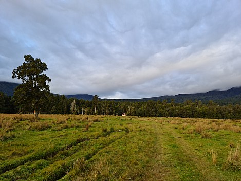
First view of Coppermine Creek Hut
Photo: Simon
2023-04-20 17.18.26; '2023 Apr 20 17:18'
Original size: 9,248 x 6,936; 15,647 kB
First view of Coppermine Creek Hut
Photo: Simon
Simon arriving at Coppermine Creek Hut
Photo: Brian
2023-04-20 17.20.02; '2023 Apr 20 17:20'
Original size: 5,472 x 3,648; 10,953 kB
Simon arriving at Coppermine Creek Hut
Photo: Brian
Brian and Simon arriving at Coppermine Hut
Photo: Philip
2023-04-20 17.20.43; '2023 Apr 20 17:20'
Original size: 4,320 x 2,880; 5,333 kB
Brian and Simon arriving at Coppermine Hut
Photo: Philip
Coppermine Creek Hut
Photo: Simon
2023-04-20 17.21.25; '2023 Apr 20 17:21'
Original size: 9,248 x 6,936; 18,954 kB
Coppermine Creek Hut
Photo: Simon
Coppermine Creek Hut
Photo: Brian
2023-04-20 17.46.58; '2023 Apr 20 17:46'
Original size: 5,472 x 3,648; 5,537 kB
Coppermine Creek Hut
Photo: Brian
Inside Coppermine Creek Hut
Photo: Philip
2023-04-20 18.25.33; '2023 Apr 20 18:25'
Original size: 4,320 x 2,880; 4,707 kB
Inside Coppermine Creek Hut
Photo: Philip

Tramping route

Trips.2023-04-16MoerakiHaastParingaCattleTrack,Maps/2023-04-20 nzm Mataketake hut to Moeraki river via tops final.gpx

Start: 08:46 Start elev: 1,233 m Max elev: 1,287 m Distance: 17.3 km
End: 15:03 End elev: 122 m Ascent: 336 m Avg moving speed: 3.1 km/h
Duration: 06:16 h Elev loss: -1,110 m Descent: 1,365 m Duration moving: 05:36 h
Tramping route

Trips.2023-04-16MoerakiHaastParingaCattleTrack,Maps/2023-04-20 nzm Haast Paringa Cattle Track Waita to Coppermine hut final.gpx

Start: 15:39 Start elev: 26 m Max elev: 56 m Distance: 6.4 km
End: 17:22 End elev: 57 m Ascent: 151 m Avg moving speed: 3.9 km/h
Duration: 01:42 h Elev gain: 31 m Descent: 117 m Duration moving: 01:38 h

add sub-page trail

tahi Page last modified on 2023 Dec 24 14:22

Edit - History - Recent Changes - WikiHelp - Search - email page as link -> mailto:?Subject="KiwiWiki: 2023-04-16 Moeraki Haast Paringa Cattle Track, Day 05"&Body=