Recent Changes - Search:

add Trips page

hide Trips

Trips


hide Topics

Topics

show Changed

Changed

Visitor's book Site map pmwiki-2.4.3

2025-02-24 Washington, Maps

for photos pages for maps page for photos pages for main page for day pages add main page trail

add sub-page trail

Approximate route on Google Maps.

Tuesday 25 February 2025, day 01 Vancouver to Crystal Mountain

Wellington, Auckland, Vancouver, Crystal Mountain

Driving Vancouver to Crystal Mountain

2025-02-24Washington,Maps/2025-02-24 nzm Vancouver to Crystal Mountain final.gpx

Distance: 318 km Duration: 05:03 h Duration moving: 04:54 h
Avg moving speed: 65 km/h GpxStat Max elev: 1,308 m
Start: 16:07 End: 21:11 Min elev: -20 m
Crystal Mountain logo

Original size: 2,592 x 2,592; 321 kB
Crystal Mountain logo.jpg

Crystal Mountain

Crystal Mountain trail map

Crystal Mountain
Crystal Mountain Northway trail map

Crystal Mountain Northway

Tuesday 25 February 2025, day 02 Ski Crystal Mountain day 1

Ski Crystal Mountain day 1

2025-02-24Washington,Maps/2025-02-25 nzm Crystal Mountain day 1 skiing final.gpx

Start: 09:06 Distance: 59.6 km Max elev: 2,063 m Duration moving: 06:17 h
End: 16:12 Max speed: 50 km/h Ascent: 6,728 m Duration ascent: 03:11 h
Duration: 07:06 h Avg dsc speed: 9.3 km/h Descent: 6,717 m Duration descent: 02:58 h

Wednesday 26 February 2025, day 03 Ski Crystal Mountain day 2

Ski Crystal Mountain day 2

2025-02-24Washington,Maps/2025-02-26 nzm Crystal Mountain day 2 skiing final.gpx

Thursday 27 February 2025, day 04 Ski Crystal Mountain day 3

Ski Crystal Mountain day 3

2025-02-24Washington,Maps/2025-02-27 nzm Crystal Mountain day 3 skiing final.gpx

White Pass logo

Original size: 512 x 512; 25 kB
White Pass logo.jpg

White Pass

White Pass trail map

White Pass

Friday 28 February 2025, day 05 Ski White Pass day 1

Driving Crystal Mountain to White Pass

2025-02-24Washington,Maps/2025-02-28 nzm Crystal Mountain to White Pass final.gpx

Distance: 242 km Duration: 03:40 h Duration moving: 03:40 h
Avg moving speed: 66 km/h GpxStat Max elev: 1,353 m
Start: 08:10 End: 11:50 Min elev: 53 m
Ski White Pass day 1

2025-02-24Washington,Maps/2025-02-28 nzm ski White Pass day 1 final.gpx

Start: 12:46 Distance: 38.5 km Max elev: 1,962 m Duration moving: 02:55 h
End: 16:15 Max speed: 60 km/h Ascent: 3,657 m Duration ascent: 01:36 h
Duration: 03:29 h Avg dsc speed: 12 km/h Descent: 3,652 m Duration descent: 01:16 h
Driving White Pass to Ashford day 1

2025-02-24Washington,Maps/2025-02-28 nzm White Pass to Ashford day 1 final.gpx

Distance: 127 km Duration: 01:55 h Duration moving: 01:54 h
Avg moving speed: 66 km/h GpxStat Max elev: 1,341 m
Start: 16:51 End: 18:47 Min elev: 255 m

Saturday 01 March 2025, day 06 Ski White Pass day 2

Driving Ashford to White Pass day 2

2025-02-24Washington,Maps/2025-03-01 nzm Ashford to White Pass day 2 final.gpx

Distance: 126 km Duration: 01:40 h Duration moving: 01:33 h
Avg moving speed: 81 km/h GpxStat Max elev: 1,325 m
Start: 06:51 End: 08:31 Min elev: 231 m
Ski White Pass day 2

2025-02-24Washington,Maps/2025-03-01 nzm ski White Pass day 2 final.gpx

Start: 09:35 Distance: 55.4 km Max elev: 1,974 m Duration moving: 06:03 h
End: 16:13 Max speed: 64 km/h Ascent: 5,599 m Duration ascent: 02:56 h
Duration: 06:37 h Avg dsc speed: 11 km/h Descent: 5,531 m Duration descent: 02:57 h
Driving White Pass to Ashford day 2

2025-02-24Washington,Maps/2025-03-01 nzm Ashford to White Pass day 2 final.gpx

Distance: 126 km Duration: 01:40 h Duration moving: 01:33 h
Avg moving speed: 81 km/h GpxStat Max elev: 1,325 m
Start: 06:51 End: 08:31 Min elev: 231 m

Seattle

Sunday 02 March 2025, day 07 Seattle day 1

Driving Ashford to Seattle

2025-02-24Washington,Maps/2025-03-02 nzm Ashford to Seattle final.gpx

Distance: 133 km Duration: 02:11 h Duration moving: 02:10 h
Avg moving speed: 61 km/h GpxStat Max elev: 525 m
Start: 09:46 End: 11:58 Min elev: -28 m
Walking in Seattle day 1

2025-02-24Washington,Maps/2025-03-02 nzm Seattle Centre walking day 1 final.gpx

Distance: 3.1 km Ascent: 300 m Descent: 294 m
Max elev: 177 m Avg moving speed: 0.8 km/h Duration moving: 03:43 h
Start: 12:24 End: 17:20 Duration: 04:56 h

Monday 03 March 2025, day 08 Seattle day 2

Walking and Cruise in Seattle day 2

2025-02-24Washington,Maps/2025-03-03 nzm Seattle day 2 final.gpx

Distance: 23.2 km Ascent: 592 m Descent: 595 m
Max elev: 35 m Avg moving speed: 3.0 km/h Duration moving: 07:44 h
Start: 08:59 End: 18:07 Duration: 09:08 h
Evening walk in Seattle day 2

2025-02-24Washington,Maps/2025-03-03 nzm Seattle day 2 evening walk final.gpx

Distance: 1.8 km Ascent: 95 m Descent: 246 m
Max elev: 182 m Avg moving speed: 1.3 km/h Duration moving: 01:23 h
Start: 19:19 End: 20:52 Duration: 01:32 h

Tuesday 04 March 2025, day 09 Seattle day 3, drive to Snoqualmie pass

Walk, monorail, and tram ride in Seattle day 3

2025-02-24Washington,Maps/2025-03-04 nzm Seattle walk day 3 final.gpx

Distance: 7.7 km Ascent: 250 m Descent: 301 m
Max elev: 33 m Avg moving speed: 2.0 km/h Duration moving: 03:49 h
Start: 09:16 End: 13:55 Duration: 04:39 h
Driving Seattle to Snoqualmie Pass

2025-02-24Washington,Maps/2025-03-04 nzm Seattle to Snoqualmie final.gpx

Distance: 85.7 km Duration: 01:11 h Duration moving: 01:11 h
Avg moving speed: 72 km/h GpxStat Max elev: 891 m
Start: 13:59 End: 15:10 Min elev: -23 m
Snoqualmie Pass evening walk

2025-02-24Washington,Maps/2025-03-04 nzm West Snoqualmie walk final.gpx

Distance: 1.7 km Ascent: 51 m Descent: 47 m
Max elev: 906 m Avg moving speed: 2.8 km/h Duration moving: 00:35 h
Start: 16:02 End: 16:46 Duration: 00:43 h
Summit at Snoqualmie logo

Original size: 500 x 500; 26 kB
Summit at Snoqualmie logo.png

The Summit at Snoqualmie

Snoqualmie Summit Central and West trail map
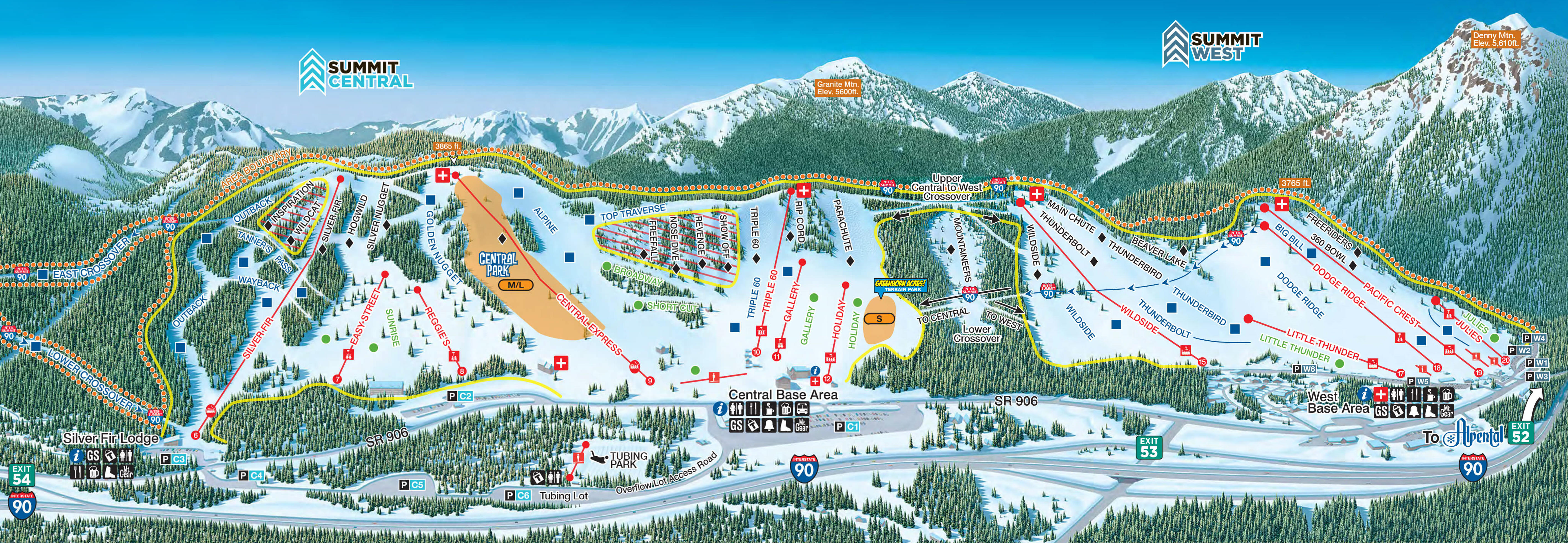
Snoqualmie Summit Central and West
Snoqualmie Summit East trail map

Snoqualmie Summit East
Snoqualmie Alpental trail map

Snoqualmie Alpental
Snoqualmie Alpental Back Bowls trail map

Snoqualmie Alpental Back Bowls
* Snoqualmie Alpental Back Bowls-2000x1309.avif

Wednesday 05 March 2025, day 10 Summit Central at Snoqualmie day 1

Driving Snoqualmie Pass to The Summit Central day 1

2025-02-24Washington,Maps/2025-03-05 nzm ski Snoqualmie day 1 driving final.gpx

Distance: 1.8 km Duration: 00:31 h Duration moving: 00:16 h
Avg moving speed: 6.6 km/h GpxStat Max elev: 901 m
Start: 08:45 End: 09:16 Min elev: 878 m
Ski Summit Central at Snoqualmie day 1

2025-02-24Washington,Maps/2025-03-05 nzm ski Snoqualmie day 1 skiing final.gpx

Start: 09:17 Distance: 69.3 km Max elev: 1,195 m Duration moving: 07:05 h
End: 17:36 Max speed: 53 km/h Ascent: 7,860 m Duration ascent: 03:53 h
Duration: 08:19 h Avg dsc speed: 11 km/h Descent: 7,691 m Duration descent: 03:06 h
Walking Summit at Snoqualmie day 1

2025-02-24Washington,Maps/2025-03-05 nzm ski Snoqualmie day 1 walking final.gpx

Distance: 0.5 km Ascent: 10 m Descent: 12 m
Max elev: 894 m Avg moving speed: 3.4 km/h Duration moving: 00:08 h
Start: 17:38 End: 17:46 Duration: 00:08 h
Alpental-Outlined-Logo

Original size: 400 x 217; 30 kB
alpental-outlined-logo.png

Thursday 06 March 2025, day 11 Alpental Snoqualmie day 2

Drive Snoqualmie to Alpental day 2

2025-02-24Washington,Maps/2025-03-06 nzm Drive Snowqualmie to Alpental final.gpx

Distance: 3.3 km Duration: 01:25 h Duration moving: 00:43 h
Avg moving speed: 4.5 km/h GpxStat Max elev: 935 m
Start: 08:26 End: 09:52 Min elev: 869 m
Ski Alpental day 2

2025-02-24Washington,Maps/2025-03-06 nzm ski Alpental final.gpx

Start: 09:53 Distance: 40.3 km Max elev: 1,650 m Duration moving: 05:02 h
End: 15:45 Max speed: 45 km/h Ascent: 6,141 m Duration ascent: 02:31 h
Duration: 05:52 h Avg dsc speed: 7.6 km/h Descent: 5,982 m Duration descent: 02:28 h
Drive Alpental to Snoqualmie day 2

2025-02-24Washington,Maps/2025-03-06 nzm Drive Alpental to Snoqualmie final.gpx

GpxStat: "2025-02-24Washington,Maps/.gpx" not a valid filename

Friday 07 March 2025, day 12 Summit East and West at Snoqualmie day 3, drive to Leavenworth

Ski Summit at Snoqualmie day 3

2025-02-24Washington,Maps/2025-03-07 nzm ski Snoqualmie day 3 final.gpx

Start: 08:22 Distance: 72.4 km Max elev: 1,170 m Duration moving: 07:07 h
End: 16:17 Max speed: 59 km/h Ascent: 7,572 m Duration ascent: 03:51 h
Duration: 07:54 h Avg dsc speed: 15 km/h Descent: 7,530 m Duration descent: 03:00 h
Drive Snoqualmie to Leavenworth

2025-02-24Washington,Maps/2025-03-07 nzm Snoqualmie to Leavenworth final.gpx

Distance: 137 km Duration: 01:47 h Duration moving: 01:46 h
Avg moving speed: 77 km/h GpxStat Max elev: 1,240 m
Start: 16:53 End: 18:41 Min elev: 312 m
Leavenworth evening walk

2025-02-24Washington,Maps/2025-03-07 nzm Leavenworth evening walk final.gpx

Distance: 2.6 km Ascent: 98 m Descent: 94 m
Max elev: 343 m Avg moving speed: 1.8 km/h Duration moving: 01:28 h
Start: 19:35 End: 21:12 Duration: 01:36 h
Stevens Pass logo

Original size: 1,200 x 538; 31 kB
Stevens Pass logo.jpg

Stevens Pass

Stevens Pass Front Side trail map

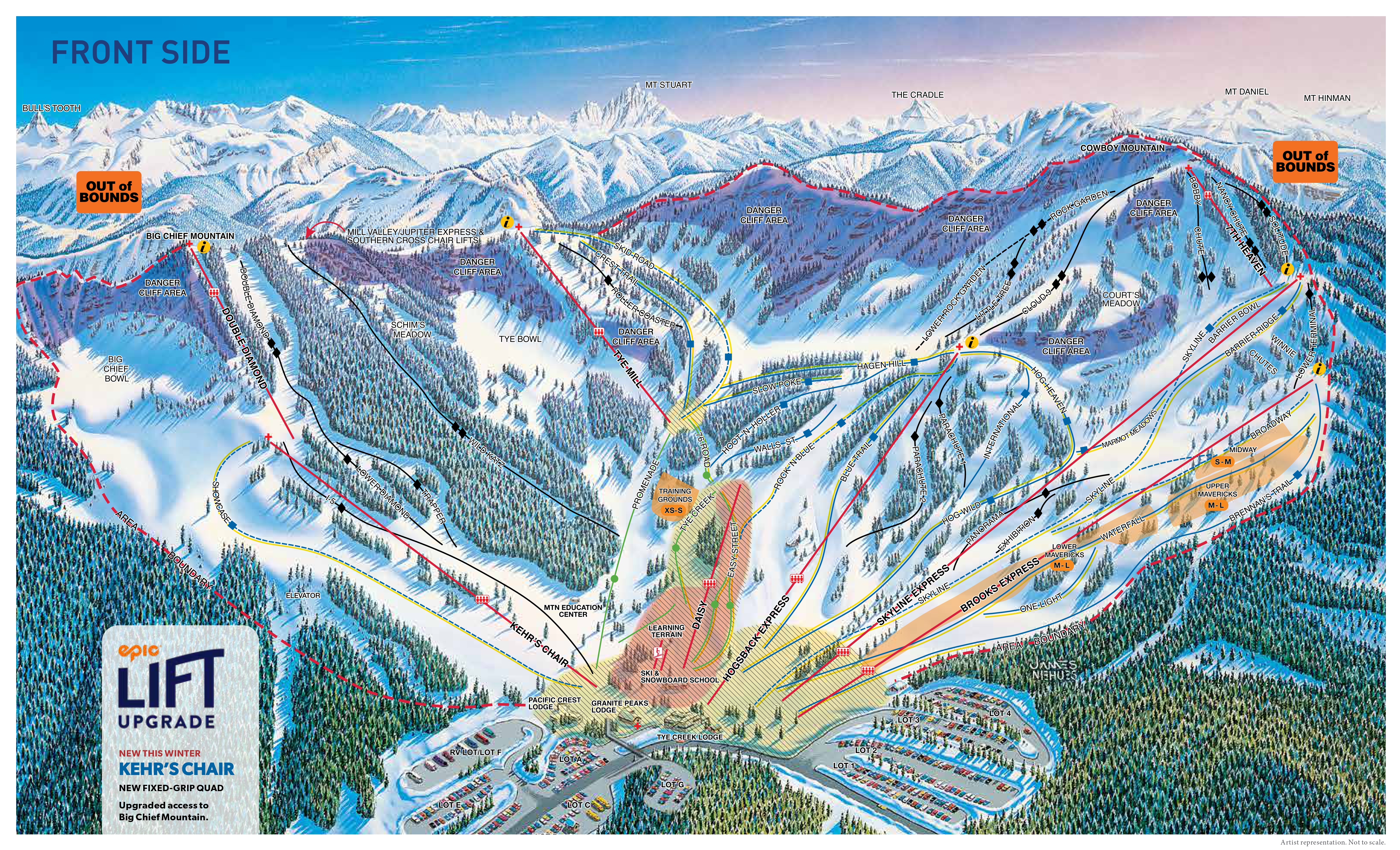
Stevens Pass Front Side
Stevens Pass Mill Valley trail map
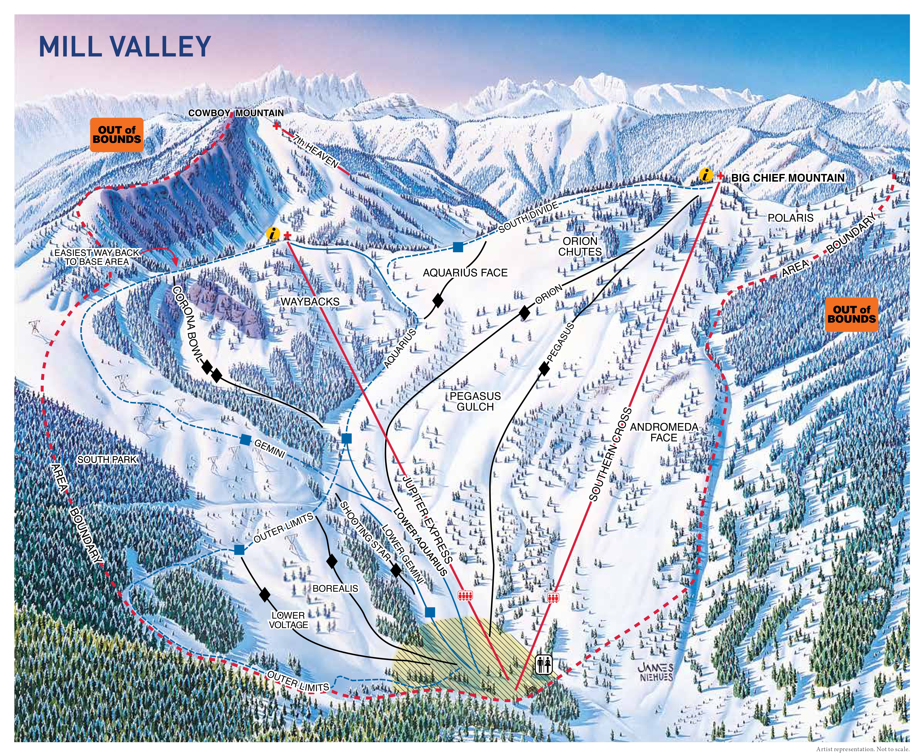
Stevens Pass Mill Valley

Saturday 08 March 2025, day 13 Leavenworth, Stevens Pass day 1

Ski Stevens Pass day 1

2025-02-24Washington,Maps/2025-03-08 nzm ski Stevens Pass day 1 final.gpx

Start: 08:29 Distance: 64.1 km Max elev: 1,596 m Duration moving: 07:06 h
End: 16:22 Max speed: 45 km/h Ascent: 6,713 m Duration ascent: 03:39 h
Duration: 07:52 h Avg dsc speed: 9.7 km/h Descent: 6,620 m Duration descent: 03:14 h
Drive Stevens Pass to Leavenworth day 1

2025-02-24Washington,Maps/2025-03-08 nzm Stevens Pass to Leavenworth day 1 final.gpx

Distance: 56.2 km Duration: 01:00 h Duration moving: 00:53 h
Avg moving speed: 64 km/h GpxStat Max elev: 1,236 m
Start: 16:24 End: 17:25 Min elev: 354 m

Sunday 09 March 2025, day 14 Leavenworth, Stevens Pass day 2

Driving Leavenworth to Stevens Pass day 2

2025-02-24Washington,Maps/2025-03-09 nzm Stevens Pass to Leavenworth day 2 final.gpx

Distance: 61.5 km Duration: 01:02 h Duration moving: 01:00 h
Avg moving speed: 61 km/h GpxStat Max elev: 1,264 m
Start: 16:20 End: 17:22 Min elev: 384 m
Ski Stevens Pass day 2

2025-02-24Washington,Maps/2025-03-09 nzm ski Stevens Pass day 2 final.gpx

Start: 08:55 Distance: 64.0 km Max elev: 1,730 m Duration moving: 06:12 h
End: 16:13 Max speed: 50 km/h Ascent: 7,734 m Duration ascent: 03:21 h
Duration: 07:17 h Avg dsc speed: 9.8 km/h Descent: 7,633 m Duration descent: 02:44 h
Driving Stevens Pass to Leavenworth day 2

2025-02-24Washington,Maps/2025-03-09 nzm Stevens Pass to Leavenworth day 2 final.gpx

Distance: 61.5 km Duration: 01:02 h Duration moving: 01:00 h
Avg moving speed: 61 km/h GpxStat Max elev: 1,264 m
Start: 16:20 End: 17:22 Min elev: 384 m

Stevens Pass to Vancouver

Monday 10 March 2025, day 15 Leavenworth to Vancouver

Driving Leavenworth to Seattle

2025-02-24Washington,Maps/2025-03-10 nzm Leavenworth to YVR final.gpx

Distance: 347 km Duration: 05:34 h Duration moving: 05:21 h
Avg moving speed: 65 km/h GpxStat Max elev: 1,243 m
Start: 08:40 End: 14:14 Min elev: -20 m

Trail map thumbnails
20241115_SV_winter-trail_map_front_side.jpg: 4849x2946, 11484k (2025 Feb 20 12:43)
20241115_SV_winter-trail_map_mill_valley.jpg: 3595x2942, 7760k (2025 Feb 20 12:43)
Crystal Mountain winter-2425-northway-map.jpg: 1247x1105, 336k (2025 Feb 20 12:27)
Crystal Mountain winter-2425-trail-map.jpg: 10619x6744, 4266k (2025 Feb 20 12:28)
Snoqualmie alpental-web-map-24-25.jpg: 2700x1557, 814k (2025 Feb 20 12:27)
Snoqualmie summit-1-east-web-map-2024-2025_cr.jpg: 2285x2121, 1056k (2025 Feb 20 12:32)
Snoqualmie summit-2-3-central-west-web-map-2024-2025_cr_stitch.jpg: 5664x1961, 2725k (2025 Feb 20 12:32)
White Pass AlpineMap2324ForLink.jpg: 2000x1600, 958k (2025 Feb 20 12:27)

add sub-page trail

tahi Page last modified on 2025 Apr 14 14:22

Edit - History - Recent Changes - WikiHelp - Search - [[?Subject="KiwiWiki: 2025-02-24 Washington, Maps"&Body="From KiwiWiki: 2025-02-24 Washington, Maps (http://kiwiwiki.co.nz/Trips/2025-02-24Washington,Maps)(approve sites) - Ski Resort Trail Maps for Washington 2025)