Recent Changes - Search:

add Trips page

hide Trips

Trips


hide Topics

Topics

show Changed

Changed

Visitor's book Site map pmwiki-2.3.37

2024-10-03 Otamatapaio Hut, Kurow, day 06

for photos pages for maps page for photos pages for main page for day pages add main page trail

add sub-page trail

Thursday 2024-10-03, day 06

Otamatapaio Hut, Kurow
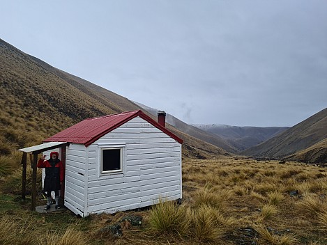
Brian outside Otamatapaio Hut
Photo: Simon
2024-10-03 07.43.06; '2024 Oct 03 07:43'
Original size: 9,248 x 6,936; 12,981 kB
2024-10-03 07.43.06 S20+ Simon - Brian outside Otamatapaio Hut.jpeg
Brian outside Otamatapaio Hut

Photo: Simon

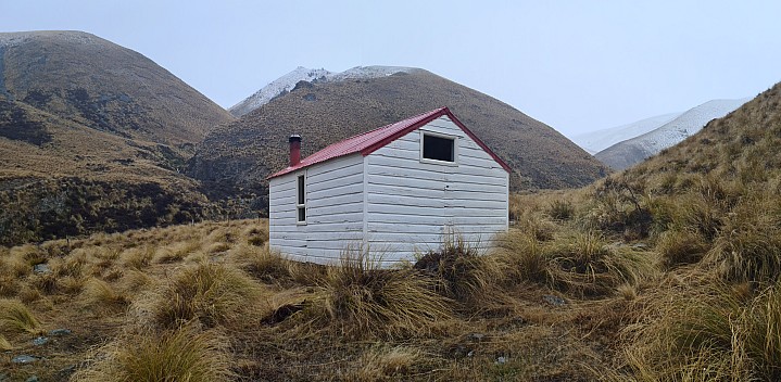
Otamatapaio Hut
Photo: Simon
2024-10-03 07.44.21; '2024 Oct 03 07:44'
Original size: 12,540 x 6,138; 11,196 kB; stitch
2024-10-03 07.44.21 S20+ Simon - Otamatapaio Hut_stitch.jpg
Otamatapaio Hut
Photo: Simon
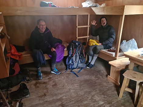
Philip and Brian in Otamatapaio Hut
Photo: Simon
2024-10-03 07.45.29; '2024 Oct 03 07:45'
Original size: 9,248 x 6,936; 9,968 kB
2024-10-03 07.45.29 S20+ Simon - Philip and Brian in Otamatapaio Hut.jpeg
Philip and Brian in Otamatapaio Hut
Photo: Simon
View up Otamatapaio Valley from the hut
Photo: Philip
2024-10-03 07.46.57; '2024 Oct 03 07:46'
Original size: 4,320 x 2,880; 4,825 kB
2024-10-03 07.46.57 P1070639 Philip - view up Otamatapaio Valley from the hut.jpeg
View up Otamatapaio Valley from the hut
Photo: Philip
Otamatapaio Hut
Photo: Philip
2024-10-03 07.47.14; '2024 Oct 03 07:47'
Original size: 4,320 x 2,880; 5,121 kB
2024-10-03 07.47.14 P1070640 Philip - Otamatapaio Hut.jpeg
Otamatapaio Hut
Photo: Philip
Otamatapaio Hut and the head of the valley
Photo: Brian
2024-10-03 07.58.06; '2024 Oct 03 07:58'
Original size: 5,472 x 3,648; 6,581 kB
2024-10-03 07.58.06 IMG_1245 Brian - Otamatapaio Hut and the head of the valley.jpeg
Otamatapaio Hut and the head of the valley
Photo: Brian
Simon and Brian heading out from Otamatapaio Hut
Photo: Philip
2024-10-03 09.46.20; '2024 Oct 03 09:46'
Original size: 4,320 x 2,880; 5,099 kB
2024-10-03 09.46.20 P1070641 Philip - Simon and Brian heading out from Otamatapaio Hut.jpeg
Simon and Brian heading out from Otamatapaio Hut
Photo: Philip
Motel at Kurow
Photo: Simon
2024-10-04 09.25.33; '2024 Oct 04 09:25'
Original size: 9,248 x 6,505; 16,135 kB; cr
2024-10-04 09.25.33 S20+ Simon - Motel at Kurow_cr.jpg
Motel at Kurow
Photo: Simon
We were in the 70s suite
Photo: Simon
2024-10-04 09.26.05; '2024 Oct 04 09:26'
Original size: 8,845 x 4,628; 9,498 kB; cr
2024-10-04 09.26.05 S20+ Simon - We were in the 70s suite_cr.jpg
We were in the 70s suite
Photo: Simon

Tramping route Otamatapaio Hut to Boundary Road

Trips.2024-09-28HuxleyOtamatapaio,Maps/2024-10-03 nzm Otamatapaio Hut to Boundary Road final.gpx

Start: 09:36 Start elev: 966 m Max elev: 965 m Distance: 14.2 km
End: 13:01 End elev: 451 m Ascent: 158 m Avg moving speed: 4.2 km/h
Duration: 03:25 h Elev loss: -514 m Descent: 665 m Duration moving: 03:20 h
Driving Otamatapaio to Kurow

Trips.2024-09-28HuxleyOtamatapaio,Maps/2024-10-03 nzm Otamatapaio to Kurow final.gpx

Distance: 41.0 km Duration: 01:44 h Duration moving: 01:40 h
Avg moving speed: 24.5 km/h GpxStat Max elev: 494 m
Start: 13:09 End: 14:54 Min elev: 191 m
Driving Kurow to Christchurch

Trips.2024-09-28HuxleyOtamatapaio,Maps/2024-10-04 nzm Kurow to Christchurch final.gpx

Distance: 269 km Duration: 04:56 h Duration moving: 04:29 h
Avg moving speed: 60 km/h GpxStat Max elev: 220 m
Start: 09:27 End: 14:23 Min elev: 20 m

add sub-page trail

tahi Page last modified on 2024 Oct 19 08:31

Edit - History - Recent Changes - WikiHelp - Search - email page as link -> mailto:?Subject="KiwiWiki: 2024-09-28 Huxley Otamatapaio, Day 06"&Body=